I love it when my interests collide in unexpected ways. I spend a lot of my professional life thinking about web map tiling schemes for ESRI ArcGIS Server web mapping applications: tile size, map projection, levels of detail, image format and so on. Outside of work I indulge my childish fascination with big, loud, fast moving machines. On a recent holiday to North Yorkshire I couldn’t resist dragging taking the family to the spectacular North Yorkshire Moors Railway where I came upon a really rather beautiful map.
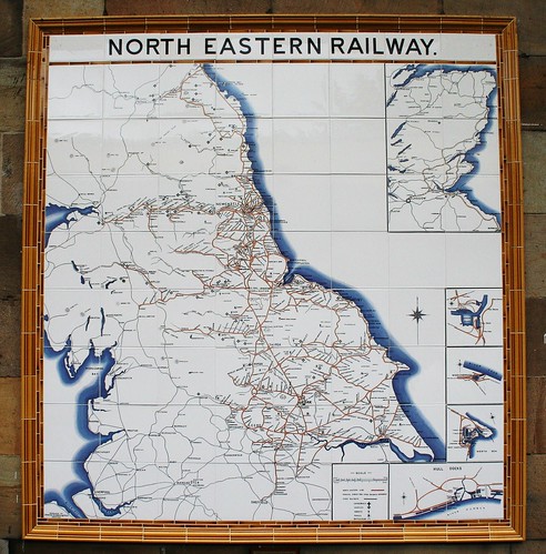
The map in question is a reproduction of an early twentieth century original,one of twenty or so produced by the North Eastern railway to show off its impressive railway network – now long since reduced to cycleways and overgrown embankments.
By itself it’s a thing of beauty, but as a geography nerd and lover of maps I rather like the unexpected parallels with modern web mapping techniques: tile size (8” square), levels of detail (special tiles for greater detail) and image format (ceramic tiles!) were all considerations for the railway cartographers of 1903 just as they are for the GIS developer in 2010. The final product is just a little more static and permanent than its modern equivalent. Thanks to a little photoshoppery by the ever-obliging Matt Toon at Google we can see how the North Eastern Railway might have approached the task today:

I was also impressed by the implicit supreme confidence in the permanence of not just the map but the railways it showed: ironic considering the surviving originals (examples remain at Whitby and Scarborough) have long outlived the lines they depict. If only I could say the same of the maps I work on whose life expectancy is usually 3 years at best, and of which no trace remains when they get decommissioned.
No comments:
Post a Comment